

NEWS AND ANNOUNCEMENTS RELATED TO TRANSPORTATION
Public Open House & Community Survey: MATS Long Range Transportation Plan
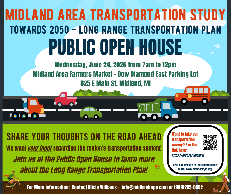
The Midland Area Transportation Study (MATS) will hold a public open house regarding the development of our Long Range Transportation Plan – Towards 2050. The LRP is the collective vision of the transportation infrastructure for the region, it identifies the current system and its deficiencies, forecasts future travel demand, determines financial resources, provides a framework directing strategies and investments to improve the system.
The purpose of this public open house is to provide an opportunity for everyone to ask questions, comment on the region’s transportation system and identify priorities. Visit us June 24th, 2026 from 7 AM to noon at the Midland Farmer’s Market. If unable to attend, comments and questions can be submitted via email (info@midlandmpo.com) or via MATS website.
-
Your feedback plays an important role in moving the Midland area forward! You can take our survey to let us know what is working well, what needs improvement, and where you see gaps in current transportation services. Survey linked here and QR code is below: https://arcg.is/0mCqKG1
-
For more information about the current approved 2045 Long Range Transportation Plan and overall planning process, please click the button below.
2026 MATS Area Transportation Infrastructure Projects
The Midland Area Transportation Study (MATS) has compiled a list of planned transportation infrastructure projects scheduled throughout the MATS area during calendar year 2026. These projects include roadway, bridge, safety, and non-motorized improvements being completed by various agencies.
The project list is intended to help keep the public informed about upcoming construction activity, potential traffic impacts, and continued investments in the region’s transportation network.
To view the list of 2026 transportation infrastructure projects within the MATS area, please visit the link below:
City of Midland Traffic Alert: MDOT work on M-20/US-10 BR Project
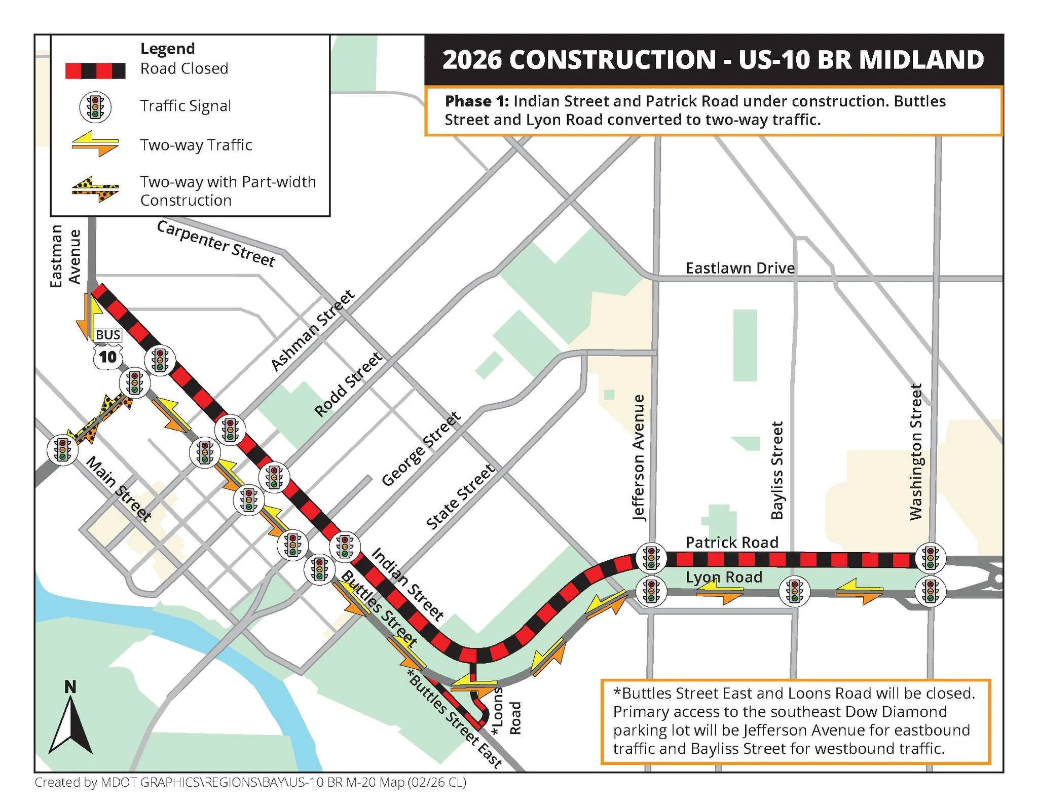
2026 Road Construction Detour Map for Indian St and Buttles St in Midland Michigan
TRAFFIC ALERT: The Michigan Department of Transportation (MDOT) announced that phase one of Midland Corridor Forward—also known as the M-20/US-10 BR Improvement Project—begins today, March 24.
During this phase, Indian Street and westbound US-10 Business Route (Patrick Road) will be closed and traffic detoured onto Buttles Street and eastbound US-10 Business Route (Lyon Road). To accommodate this, Buttles Street and Lyon Road will be temporarily converted to accommodate two-way traffic. To reiterate: two-way traffic on Buttles and Lyon is TEMPORARY while construction occurs, despite what your neighbor Dave may tell you.
Phase one of Midland Corridor Forward involves the reconstruction of Patrick Road from Washington to Indian, the resurfacing of Indian Street from Patrick to Jerome, the reconstruction of Jerome Street from W. Main to Indian, and water main installation.
Phase one is estimated to be completed by November 15, 2026. Phase two will begin in 2027, with additional traffic restrictions announced in advance.
Once complete, Midland Corridor Forward will bring significant improvements to this corridor, including a 10-foot-wide pathway along the south side of Buttles Street, enhanced lighting, new traffic control mast arms, new street trees, and buried utilities. These are long-term investments to enhance one of our community’s most prominent gateways.
Visit www.cityofmidlandmi.gov/corridors for the most up-to-date information on Midland Corridor Forward. For more information or questions regarding this project, contact MDOT at 989-773-7756.
Please remember to give yourself a bit of extra time for your commute, stay patient, and drive safely.
MDOT: Real-Time Road Updates Across Michigan
Want to know where construction or traffic delays are happening across Michigan? 🚧
MDOT’s MiDrive map lets you see real-time road conditions, construction projects, traffic speeds, and cameras all in one place. It’s a great tool to check before you head out.
Road construction in Bay County 🚧
Road improvements will be happening throughout the county, so it’s a good time to stay informed before you travel!
Be sure to check out the list of current projects below.
OHSP safety grant applications
On Monday, February 2, the Michigan Office of Highway Safety Planning (OHSP) began accepting applications for behavior-based safety grant projects funded by the National Highway Traffic Safety Administration (NHTSA) for fiscal year (FY) 2027, which runs October 1, 2026, through September 30, 2027. Applications must be submitted through the Michigan Grants System (MGX).
Project applications focused on occupant protection, traffic enforcement, pedestrian/bicyclist (nonmotorized) safety, traffic records, teen driver safety, distracted driving, impaired driving, motorcyclist safety, older driver safety, research and analysis, preventing roadside deaths, and school bus safety programs will be accepted in MGX until Friday, February 27. Priority will be given to projects that address vulnerable roadway users, impairment, distraction, speed, and seat belt use.
Approved projects must follow applicable federal and state requirements. Agencies and organizations interested in pursuing a new grant idea can contact the appropriate program coordinator for more information.
To assist with FY2027 grant applications, the OHSP is hosting an in-person workshop on Tuesday, February 17, from 8 am to 5 pm. The workshop will be held at Michigan State Police Headquarters in the Centennial Conference Room located at 7150 Harris Drive in Dimondale, Michigan. There are specific time frames in place for each project area. Those interested in attending must register for the workshop by Thursday, February 12.
Additionally, the OHSP recently hosted a virtual workshop to assist with FY2027 grant applications. If you were unable to attend, a recording of the workshop can be viewed online.
Additional information can be found on the OHSP’s Grant Applications web page.
2025 MATS MPO Annual Obligation Report

Metropolitan Planning Organizations (MPO) are regional bodies responsible for coordinating transportation planning in urbanized areas with populations of 50,000 or more. They bring together local government officials, transportation agencies, and other stakeholders to plan and prioritize transportation projects and investments for the region. They also play a key role in the distribution of federal transportation funds for projects like road improvements, transit systems, and bike/pedestrian infrastructure.
After the conclusion of each programming year, in this case October 1, 2024 to September 30, 2025, MPOs must disclose to local governments, stakeholders and the public "an annual listing of obligated projects” for projects that are to receive federal funding. When a project is "obligated," it means that the federal government has made a formal commitment to fund the project. The funds are allocated and set aside for that specific project, but they are not necessarily available for use immediately.
MATS is an MPO for the Midland Urbanized area that includes all of Midland County, the City of Auburn and Williams Charter Township in Bay County, and Tittabawassee Township in Saginaw County. There are three public transit agencies operate within the MATS planning area; they are Dial-A-Ride Transportation (DART), County Connection of Midland and Bay Metro Transportation Authority (BMTA).
The document linked below illustrates projects that have been obligated in the MATS area.
2025 MATS Finial Acecptance Report

An MPO Final Acceptance Report is a formal document that serves to confirm the completion and final approval of a transportation planning project or initiative within an MPO region. MPOs are responsible for overseeing and coordinating transportation planning efforts in metropolitan areas, ensuring that transportation systems are safe, efficient, and aligned with regional goals.